


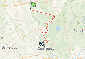
J2.1 - Saint Maurice - Commercy

Gauthier B
User

Length
78 km

Max alt
415 m

Uphill gradient
1652 m
Km-Effort
99 km

Min alt
192 m

Downhill gradient
1619 m
Boucle
No
Creation date :
2023-06-07 15:45:22.542
Updated on :
2023-06-08 14:06:54.169
0m
Difficulty : Very easy

FREE GPS app for hiking
 SityTrail
IGN / Geographical institutes
SityTrail Plus
The world is yours!
About
Trail 4x4 of 78 km to be discovered at Grand Est, Meuse, Les Monthairons. This trail is proposed by Gauthier B.
Positioning
Country:
France
Region :
Grand Est
Department/Province :
Meuse
Municipality :
Les Monthairons
Location:
Unknown
Start:(Dec)
Start:(UTM)
676006 ; 5437015 (31U) N.
Comments